
The Most Reliable Ways to Find Property Lines Before Installing a Fence or Garage
Before building a fence or putting up a garage, you need to know exactly where your property ends and your neighbor’s begins. Getting this wrong can lead to expensive problems, including having to move a structure you just paid to build. Finding your property lines before construction starts protects your time, your money, and your relationship with the people next door.
Using Existing Survey Records and Property Documents as a Starting Point
A good first step is to look through the paperwork that came with your home. When you bought the property, you likely received a package of closing documents. Inside that package, there may be a copy of a prior survey, a plat map, or a legal description of the land.
A plat map shows how a subdivision was divided into individual lots. It includes lot dimensions, boundary lines, and the layout of streets and common areas. Reviewing the plat for your neighborhood can give you a general idea of your lot’s shape and size.
Deeds often include a written legal description of the property boundaries. This description uses measurements and reference points to define where the lot begins and ends. Reading a legal description without survey training can be difficult. The measurements in older documents may also not be precise enough to rely on alone.
These records are useful as background information. They can help you understand the general layout of your property. They are not a substitute for physical verification on the ground, especially when building close to a boundary line.
Locating Property Corner Markers and Boundary Monuments on the Ground
One direct way to find property lines is to look for physical markers placed when the lot was first surveyed. These markers are called property corner monuments. They are usually iron pins or rods driven into the ground at lot corners.
Iron pins are small metal stakes, typically half an inch to one inch in diameter, that surveyors install at boundary corners. Over time, they can get buried under soil, covered by grass, or hidden by landscaping. A metal detector can help locate pins that are not immediately visible.
When you find a corner marker, do not move it or disturb it. These monuments have legal significance. Moving a survey monument is illegal in most states and can create serious boundary disputes. If a marker appears to be missing or damaged, a licensed surveyor should be contacted to assess the situation.
Finding all four corners and measuring between them can help you trace the boundary lines. Irregular lots may have more than four corners. This works best when the corners are clearly marked and the lot is a simple shape. On lots with multiple corners or unclear markers, this method has real limitations.
Understanding Why Fences, Landscaping, and Driveways Do Not Always Follow Property Lines
Many homeowners assume that a fence between two properties marks the legal boundary. This is one of the most common misconceptions about property lines, and it causes a lot of problems.
Fences are often built without a survey. The person who installed the fence may have placed it a few feet inside their property. Or they may have simply guessed where the line was. Over time, that fence becomes a visual reference for the whole neighborhood, even if it does not reflect the actual legal boundary.
The same applies to driveways, hedgerows, tree lines, and retaining walls. These features follow the decisions made by whoever installed them, not the recorded legal boundaries. A driveway that appears to end at the property line may actually cross onto a neighboring lot. A row of bushes that seems to separate two yards may sit entirely on one person’s property.
Relying on these visible features when planning a fence or garage is risky. If your new structure ends up on a neighbor’s land, you are responsible for relocating it, regardless of what fence you followed.
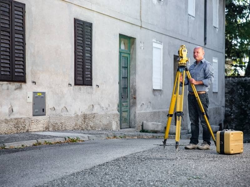
When a Boundary Survey Becomes the Most Reliable Option
When records and markers are not clear enough to build with confidence, a boundary survey is the most reliable next step.
A licensed surveyor researches the recorded documents for your property and the surrounding lots. They locate existing corner monuments, take precise measurements, and calculate the legal boundary locations using current survey methods and equipment. The result is a survey document that shows the verified boundary lines and the location of any improvements relative to those lines.
According to the National Society of Professional Surveyors, boundary disputes are among the most common legal issues involving residential property. Many of those disputes could have been avoided with a survey completed before construction began.
A boundary survey is especially important before building along a shared line. This includes fences, garages, sheds, and driveways placed near the lot edge. Survey costs are almost always less than the cost of moving a structure placed in the wrong spot.
Avoiding Costly Placement Mistakes Before Construction Begins
Building in the wrong location creates problems that are hard to undo. A fence that crosses onto a neighbor’s property can trigger a legal dispute and may need to be removed and rebuilt. A garage placed too close to the property line may not pass a permit inspection, especially in areas with minimum setback requirements. A driveway that encroaches on neighboring land can complicate future real estate transactions for both properties.
These situations all share the same root cause. The property owner did not confirm the boundary location before construction started. Checking property lines early, whether through existing records, corner markers, or a boundary survey, protects the investment being made in the improvement.
Beyond the financial risk, boundary mistakes also put a strain on relationships with neighbors. These disputes are hard to resolve and can affect how you feel at home for years. Taking the time to confirm property lines before any construction begins avoids that outcome from the start.
Frequently Asked Questions
How can I find my property lines before building a fence or garage? Start by reviewing any surveys, plats, deeds, or subdivision records that came with your property. You can also look for iron pins or corner monuments at the edges of your lot. If those steps leave uncertainty, a boundary survey from a licensed surveyor provides the most reliable confirmation of where your property lines are.
Can I use an existing fence to determine where my property line is? No, not reliably. Many fences are placed inside the property line or were installed without a survey. A fence reflects where the previous owner chose to put it, not where the legal boundary actually sits. Using a fence as a reference for new construction can lead to placement errors.
What are property corner markers? Property corner markers are physical monuments, usually iron pins or rods, placed at the corners of a lot during a survey. Surveyors use them to locate and verify boundary lines. They have legal standing and should never be moved or removed.
When should I order a boundary survey before construction? A boundary survey is worth ordering before building any improvement close to a property line, including fences, garages, sheds, additions, and driveways. The earlier in the planning process you confirm the boundary location, the less risk there is of building in the wrong spot.
Why is verifying property lines important before construction starts? Confirming property lines before building helps prevent encroachments onto neighboring land, supports accurate permit applications, and reduces the chance of disputes with neighbors. It also protects you from the cost of relocating a structure that was placed in the wrong location.